
|
Zilpo Scenic Byway, Cave Run Lake Last weekend, Wendy and I decided to we needed to get out and see some nature. Due to time restraints, and other responsibilities we could not take an overnite trip. After throwing out a few choices we decided to drive up to Cave Run Lake. About a year earlier JB and myself, had driven up to check out the Zilpo Scenic Byway, and of course Tater Knob Fire Tower. Wendy and I had also been up to the tower before, but it seemed like a good trip for the day so we headed out. Zilpo is probably most easily accesed from US Highway 60. Driving through Salt Lick you will see signs for the turn off on to state route 211. A short few miles up the road will bring you to another sign, and a left hand turn. From here it is just a matter of following the signs, and enjoying the scenery. Our first stop was at stop number one, Clear Creek Lake. This is basically a small point for fishing. I believe this area is closed to motorized boats, or maybe it is just electric motors. Anyhow, the lake is quite beautiful, and the wildlife is rich, we saw a few geese on the water, and several people were fishing. We continued on driving past the Clear Creek Picnic Area, and Clear Creek campground, intending to stop here on our way back, and entered into the Pioneer weapons Area, of the forest. This area is opened for hunting with muzzle loader type rifles. The next stop we made was at stop number 4, the Forest Renewal Overlook. The overlook has a small sign that explains the effects man has had on the forest. The only problem we encountered here was that do to the overgrown state of the trees, the overlook was nearly impossible to see. In fact wendy could not see it at all with out standing on the JEEP. After taking a few pictures, at the overlook we proceeded on to Tater Knob Fire Tower. The Fire tower is usually visible from the first pull off. This first pull off, is small, and has a plaque with some basic information on the fire tower. Just past the Pull off, there is a small road, that leads back to the Parking Area for those wanting to venture to the top. We pulled into the parking area, noticing that there was only one car there. The skies, were getting kinda dark, but we decided we could get up and back, before the storm hit. Taking off up the trail the first thing you encounter is a large 3 panel sign that gives various information about the fire tower, and other geographic items of interest. Tater Knob fire tower was built in 1934 and is the only remaining fire tower in the DBNF open to the public. The Tower is 35 foot tall and was restored in 1993. The trail begins at the signs, and goes to the top of tater knob. Most of the trail is stairs, the first section is a series of 137 steps, at the top of this section thier is a bench. Here the trail scrambles through a few boulders, and then continues up 68 more steps until it reaches another bench, and nice little overlook. From this point it is 16 stairs to the base of the tower. Climbing the tower is an additional 42 steps for a grand total of 263 steps to get from the parking area to the top of the tower. Did I mention it was 263 steps?? I felt every one of them. At the half way point we encountered, 2 guys coming down, they were very polite, mentioning that they were getting off the tower before that electrical storm got there. In retrospect I guess that was a pretty good way of thinking. Once we arrived at the top of the tower the view was quite impressive, looking out over the forest, as well as a small section of the lake. The dark clouds were gently rolling, and lightning was visible way off in the distance. We walked around the tower, a couple of times, noticing that we could just barely see the parking area, from one point. At the bottom of the trail we took the other short walk back to the spring that runs from underneath Tater Knob, thier is a small plaque hear with infromation about Native Americans, and the Early Settlers using the spring for water, returning to the parking area we headed off to the last stop on the byway. The last stop is a pull over for a view of the lake, their is another plaque here that describes the lake, and tells about the dam being built. From here it is a short drive to the Zilpo Recreation Area, this is a fee area. We turned around and headed back. Along the way back we stopped for a short nature walk, that provided a few simple signs, that explaind symbols used in marking trails. We then headed back to the Clear Creek campground. This is a primitive self serve pay area, with approximately 21 sites, it is strictly first come first served. Just down the road is Clear Creek Picnic Area, were you can see the remains of an old iron blast furnace. Another interesting site is the small foot bridge, crossing the stream. This bridge is one of kind, made using experimental techniques by the University of Ky. After walking around here for awhile, we headed back onto the road, and back to good ole Winchester. Those of you that are looking for a nice day outting, will enjoy a nice side trip down the Zilpo Scenic Byway. I think our trip porbably was about 2 and a half hours long, but could have been longer if we had taken time to travel more of the trails in the area. The Clear Creek campground was quite well maintained, and would be a good place to stay if you are not into "backwoods" camping, and the Picnic Area would be excelant for just that. All and all, I enjoy the area, and usually make a trip up there a couple of times a year. Arthur Sharp |
Clear Creak Lake  Forest Renewal Overlook 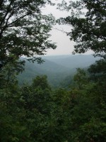 Forest Renewal Overlook 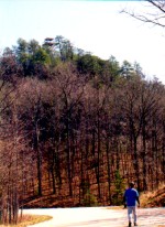 Tater Knob Tower as seen from road 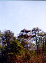 Tater Knob Tower as seen from road 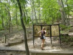 Tater Knob Trailhead 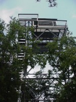 View from under Tater Knob Tower 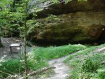 Tater Knob Spring 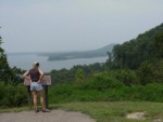 Wendy at Last Stop on the Byway 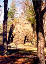 Blast Furnace at Clear Creek Picnic Area 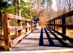 JB on the experimental bridge Story and Photos by Arthur Sharp |