
|
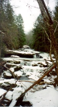
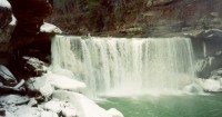
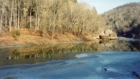
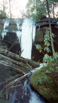
Pre-Spring Tune Up on the Cumberland River Spring is only a few weeks away, and you know what that means, the fair weathered hikers will be coming out in force once again. Some will be looking for a tune up hike before heading out to bigger adventures planned for vacations during spring break or later on in the summer. This requires a warm-up hike that has some mileage, but no serious elevation gains. The perfect trip is a stretch of the Sheltowee Trace Trail between County Road 6234 and Laurel River Dam. This trip has all the eye candy with none of the strenuous ups and downs found in many hikes with much less to offer! This trip is truly about having your cake and eating it too. This 20-mile trek will give you river access for all but a few miles, five reliable waterfalls, a multitude of wildlife viewing opportunities, two strategically placed overnight shelters, and a well marked trail. What more could one ask for after coming out of winter hibernation? This circuit hike can be done in either direction, but we decided to start from County Road 6234 and head down the Cumberland River, then upstream on the Laurel River to the Dam where another car was waiting. Late Friday night, we setup camp at the end of a primitive dirt county road. The conditions were not great, but we didn't want to start hiking in the dark and miss any of the scenery. Section one: County Road 6234 to Cumberland Falls State Park - Approx. 5 Miles The trail started a couple hundred yards back up the road from the river, marked by some pink ribbon and a couple of large rocks. The telltale sign of the Sheltowee Trace was also present, the turtle blaze with a white diamond below it. For the first quarter mile or so, the trail progressed above the river. This was mixed hardwood forest with a few rock houses. The trail then dropped back down to the river where it followed along a rock shelf right above the river's edge. The scenery was quite nice, but somewhat lessened by the large amount of garbage present along the banks. Shortly after the shelf, the trail follows a along a unimproved road along the river where there many fish camps. After that, one ends up on the State Nature Preserve. 2.5 miles further, Hwy 80 near Cumberland Falls State Park is reached. Section Two: Cumberland Falls to Bark Camp Creek - Approx. 8 Miles Obviously, this is one of the most beautiful and populated parts of the hike. Cumberland Falls is simply Magnificent. It is the second largest falls east of the Mississippi River. It is also the site of the moon bow, one of only two in the world that appears on a predictable schedule. After leaving Cumberland Falls, the trail continues on for the next three miles almost always in sight of the river to the junction with Dog Slaughter Falls Trail. Here a short side trip will take the scenery lover to a wonderful waterfall tucked away on a side drainage called Dog Slaughter Creek. This side trail will also provide access to FSR 195 if a smaller hike is desired. My dog seemed to make it through the area just fine, so don't worry about the name. Another two miles down the Sheltowee, and the hiker finds a safe haven of which there are only four of in the Daniel Boone Forest; an actual backcountry shelter. This one being Star Camp, located by the third waterfall on the trip, Star Falls. At Star camp, the shelter will sleep six, and there is a flat spot where another tent could be setup. A privy is also located at the camp, making the need to dig a hole in the rocky soil unnecessary. The next 2� miles take you past a smaller waterfall at Devil Creek, then to another backcountry shelter near Bark Camp Creek. At the Creek itself, there is a set of several small falls stair-stepping down towards the river with an opportunistic view of the entire setting from the bridge. At the far end of the bridge one has several choices. The hiker can either continue down the Sheltowee to the Laurel River Boat Ramp, Hike up the ridge following an alternate route of the STT used in times of high water, or head up Bark Camp Creek following a trail an additional 2.3 miles upstream to FSR 195. Section Three: Bark Camp Creek to Mouth of the Laurel Boat Ramp - Approx. 4 Miles This section of the trail travels along the river throughout its entirety. There are several cliffs and rock houses along the way with no major elevation gains or drops throughout the section. Just before the STT reaches 1277, it crosses Fishing Creek where the trail meets a side trail that is used for times of high water. The flood route connects back to the Sheltowee at Bark Camp Creek. Section Four: Mouth of Luarel Boat Ramp to Laurel River Dam - Approx. 3 Miles The trail travels down State Road 1277 for Approx. 1/3 mile before making a right turn to a gated road that travels above Laurel River. The trail leaves the road and then crosses Whitman Branch. Then the Sheltowee moves uphill past a few rock houses, some that have initials of people dated 1935. After making the trip to the top of the ridge, the trail follows Forest Service Road 4058 for a little bit. Afterwards the trail proceeds across a little creek and back to hwy 1193, crosses the bridge over the spillway, and back to the parking area above the dam. How to Get There From Louisville, take I-64W to Lexington. From Lexington, take I-75S to Exit 25 at Corbin (US25 W). Turn right and follow US 25 W to 1193. Turn right on 1193 and follow to Laurel River Dam. This is where we left the car we hiked to. Follow 1193 back to US 25 W and turn right. Follow US 25 W to 90 and turn right. Take 90 to 700 and turn left. Take 700 and turn left on 6234. Follow to just above the river. The trail begins above the river and heads downstream. Shelters/Campsites The best place to camp is either at Star Camp or Bark Camp Shelters. These shelters are for everyone, so plan on the possibility of camping with strangers when you go. There are also flat spots for tents at each shelter site, so it might not be a bad idea to bring a tent along just in case the shelters are full. Because of the 200' restriction on camping near water sources, camping on the flat flood plain along the banks of the river is not a good idea even though there are plenty of "fish camps" closer to the river than the rules suggest. Leave No Trace Seasons to Go Anytime of year is the best time to go camping in Kentucky. More Information Stearns Ranger District (County Road 6234 to State Wildlife Preserve) PO Box 429, US Hwy 27 North Whitley City, KY 42653 Phone: (606) 376-5323 Cumberland Falls State Resort Park (Cumberland Falls Area) 7351 Hwy 90 Corbin, KY 40701 Phone: (800) 325-0063 London Ranger District (Cumberland Falls to Laurel River Dam) 761 S. Laurel Road London, KY 40744 Phone: (606) 864-4163 Article by Timothy Brothers If you want to share some of your experiences, or would just like to comment on this article you can make a post in our Backpacking/Hiking message forumn. |
    |