|
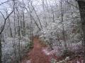
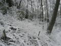
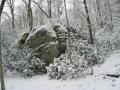
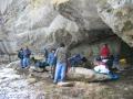
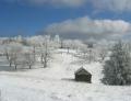
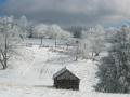
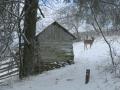
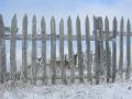
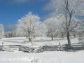
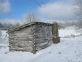
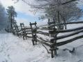
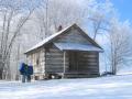
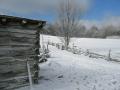
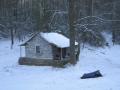
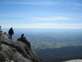
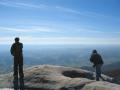
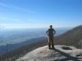
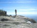
Ridge Trail All Fall I looked forward to going backpacking over the Thanksgiving holiday. My plans, however, were not set until the evening before I left. First, I wasn’t sure until the day before whether a friend (shuttle potential) was going to go. He couldn’t make it so I was solo. Then there was the matter of the weather. I had been monitoring various weather web sites all week, and all forecast a “wintry mix” for Friday and Saturday. Predictions of five inches of snow in the highlands of West Virginia ruled out one possible destination, the Cranberry Wilderness, and flash flood watches for the Cumberland Plateau ruled out the Big South Fork (stream crossings in sub-zero temps didn’t sound that fun). The fact that it was bear and boar hunting season (packs of pit bulls) in western North Carolina made me wary of the Joyce Kilmer Wilderness. Thus on Thursday evening I decided on the Ridge Trail in Cumberland Gap National Park, even though I expected to have to do an out-and-back route. Friday morning I packed up and headed south on I-75. Soon I encountered steady rain and strong gusts, and by Corbin I started to see some frozen precipitation on the windshield. With irrational exuberance, I looked forward to field-testing my gear in nasty conditions. I decided I would cheat the mountain a little and start at the Pinnacle Overlook parking lot (thereby avoiding an initial ascent). My plan was to stay at the Gibson Gap backcountry site Friday night and at Martin’s Fork Saturday night, and then head back to the overlook on what promised to be a very long Sunday. When I picked up my permit at the Visitor’s Center the ranger told me that a group of ten scouts had also reserved space at Gibson Gap. I admit I was not excited about the prospect of sharing camp with such a large group of youngsters. I suspected, wrongly it turned out, that the weather might dissuade the scouts from making their trip. These scouts were indeed hardy and earned my respect over the course of the weekend in what were certainly challenging conditions. After picking up my permit I headed up to the Pinnacle Overlook parking lot. I loaded up and hit the trail about 1 PM. There was zero visibility at the overlook, with harsh winds, falling temperature and light snow. By 3 PM, blowing snow had covered the trees. I soon passed two men who identified themselves as leaders of a scout troop from Winchester, Kentucky, which was making its annual Thanksgiving trek of the Ridge Trail. They had dropped off the scouts and an adult earlier at the overlook trailhead, and taken two vehicles to the Civic Park trailhead for a shuttle. Later, they generously offered me a ride with them from the Civic Park back to the overlook, which meant I could hike the entire Ridge Trail with no backtracking! After a side-trip to Skylight Cave, I arrived at the Gibson Gap campsite. The scouts, a group of 8 or so, had occupied the lower, protected tent sites, so I had to set up camp at a fairly exposed site closer to the crest of the mountain. The temperature had continued to plummet, and the wind was roaring. (I think the forecast of 25-30 mph gusts was accurate.) After staking down my bivy, I quickly prepared and consumed so-so freeze-dried kung pao chicken. Soon afterwards I retreated to my tent to escape the biting wind, and listened to UK whoop up on Tennessee Tech. The wind pounded and rocked my North Face Trek Bivy all night, and snow continued to fall. I think I gain a little knowledge on almost every backpacking trip I take and this one was no exception. My first lesson learned was that if you bring a water reservoir inside your tent at night to keep your water from freezing, make sure that the bite valve does not get under either your bag or pad where it can be compressed by your weight and open! Better yet, detach and drain your drinking tube. I woke up at about 2:30 with my lower back damp and cold. My water reservoir had discharged about a ½ liter, which soaked a small area of my down bag. I soaked up the water as best I could with a camp towel, turned my bag so the wet spot was on my side, and covered the wet spot with some fleece for insulation. Overnight, my body heat dried the bag pretty well, and my towel froze rock solid. Can you say dead weight? The next morning was friggin’ cold, with one of the scouts reporting a reading of fifteen degrees. The wind continued to whip, but the snow had tapered off to flurries, with an accumulation of a couple of inches in most places. After some hot tea and oatmeal, I broke camp and hit the trail. With the exception of a couple of stragglers, the scouts had gotten off earlier than I had. I busted tail on the trail to keep warm and made good time considering the snow cover. I’m glad I had my trekking poles. I ran into the scouts again just off Ridge Trail at a rock shelter named Indian Rock. It was about 11 AM, and the scouts had broken out their stoves (and one heater!) for a hot lunch. I also added some fuel to my human engine and headed out towards Hensley Settlement ahead of the scouts. Rather than taking the Ridge Trail, I took the scoutmaster’s suggestion and followed a less-used path that continued beyond Indian Rock to the Settlement. The trail was very scenic and crossed what I believe were the headwaters of Shillalah Creek. The trail was not clearly marked and I doubt I would have known to take it but for the scoutmaster’s tip. Shortly before I arrived at the Settlement the sun started peaking out. Also, as I had by then dropped off the crest of Cumberland Mountain into the upper portion of the valley between Cumberland and Brush Mountains, the wind had died down significantly, and I began to feel almost comfortable. When the trail broke out into the clearings of the Settlement, the sky was an electric blue mixed with thick gray and white clouds. Deer abounded and, obviously aware of their protected status within the Park, paid hardly any attention to me. The spectacular winter scenery before me was a more than adequate reward for the challenge of the journey. After exploring Hensley Settlement for a while, I got back on the Ridge Trail and headed for Martin’s Fork. I arrived at my destination around 1:30 and proceeded to set up camp next to the cabin. The cabin’s back porch provided a great place off the snow to spread my gear out and made up for my failure to bring either a tent with a vestibule or a tarp. (Another pearl of wisdom gained. Hey, I’m a recent convert to snow camping.) I had enough time to bushwhack down to the creek and enjoy the majesty of huge hemlocks coated with snow. After dinner, I warmed up around the scout’s fire, put the contents of my flask to good use and hit the bag. The following morning was cold but not nearly as bitter as the day before. After breakfast I packed up and headed off to Sand Cave, which is simply impressive. Photos (at least mine) just don’t capture its scale. By this point in the weekend, some of the scouts were fading and didn’t make the trip down to the cave. They instead headed for either White Rocks or their ultimate salvation, the scoutmaster’s truck at the Civic Park trailhead. I arrived at White Rocks at about 11 AM, dropped my pack and scrambled up to the top of the rocks. It was extremely windy, although the wind, which had come from the north earlier in the weekend, was now coming from the south. (Later in the day, the temperature would rise above freezing for the first time in 48 hours!) I soon was joined by a few of the scouts and their leader and snapped a couple of pics of them as they were posing for their own pictures. The view from White Rocks was somewhat hazy, but I coud still see six or seven rows of mountains. After taking in the views for a half hour or so, it was time to head down the mountain. From the Ridge Trail, I took the Ewing Trail to Civic Park, where the scout leaders had left a couple of shuttle vehicles. I caught up with some of the scouts who had skipped White Rocks, who greeted sight of the vehicles with shouts of relief and talk of what and how much they planned to eat at Ryan’s Steakhouse in Middlesboro. We waited for the rest of the scouts before packing everyone and everything (4 adults, 7 scouts, I think, plus packs) into 2 trucks and heading back to the Pinnacle Overlook. I thanked the scout leaders’ for the lift, took in a quick view from the overlook, and headed home. All in all a memorable adventure. Anyone for some winter backpacking?
Kentucky: Tennessee: Virginia:
Write to: |
|
Park Info:
Cumberland Gap National Historical Park Photos:
All photos ©2003 John Park |